Little Bear Creek from Hubbard's Landing
Saturday, March 4, 2006 brint.adams@us.army.mil
Today was just another spring day in paradise with sunny skies, only a slight breeze and temperatures rising from 45 degrees in the early morning to 70 degrees in the afternoon. Carl, Jimmy and I met at the Stagecoach Cafe in Stockton, a few miles north of I-65 exit 31 on Hwy 225. Once assemblied, we went up Hwy 59 a few miles and turned left on the county road to Hubbard's Landing.
Once we pulled in around the store, it was evident the Tensaw Lake water level was up to a partial flood level. The road down to the summer cabins, which were all on stilts, was well under water as was the boat launch area. We parked and talked with the proprietor for awhile about conditions in the delta and left without having to pay the typical $5.00 launch fee. We loaded up our boats and took off upriver, heading for the top end of Tensaw Lake.
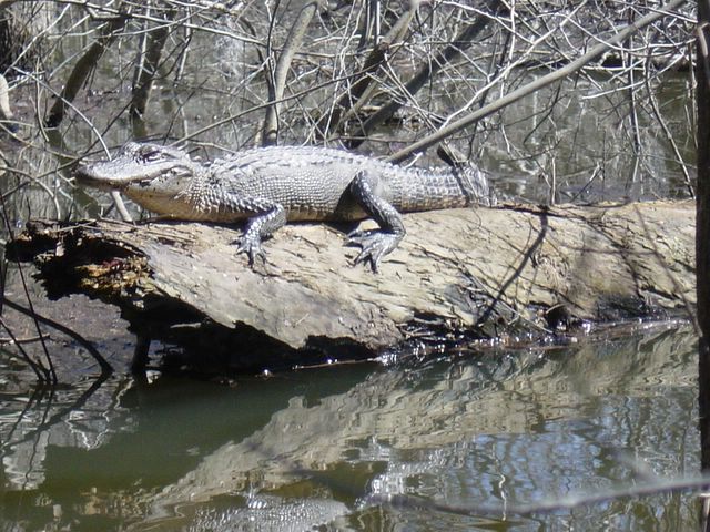
There was a noticeable current, so I kept off to the side, dipping in and out of the treeline where there was room to check out the flooded timber. We passed the normal left turn into Big Beaver Creek and continued north to Farris Creek. It was apparent no one had been there in quite some time. We proceeded around the various treefalls, at least not having to pull out our saws. After about a half mile of picking our way around, trying to guess where the creekbed was, Jimmy noticed a small gator sitting up on a log, watching us go by. I turned around and pulled in close by for a few photos, while he held his pose and never blinked.

Little Gator Buddy
We finally either ran out of creek or lost it somehow and decided to turn around. I dragged out three decoys and a nice water cooler and carried them along on the back deck of my boat.
We paddled south on Tensaw and turned right on Big Beaver Creek. We passed up the entrance to Globe Creek, continuing to paddle around the several s-turns until reaching the mouth of Bear Creek. It was around 1:00 PM, and with high water everywhere, we decided to eat lunch at the Canal Island floating platform. To get there we continued west on Big Beaver and eased to the south down Little Lake, taking the first right into the Canal Island loop. We had paddled 7.5 miles so far and Carl decided he had enough for the day and stayed on the platform to read and enjoy the sunny afternoon. It was so beautiful out, I wanted to explore some areas I had only seen on the map before. Jimmy headed back to Hubbard's Landing, so we parted ways at Bear Creek.
Since I was by myself, I decided to turn the afternoon into a fast workout, while exploring new territory. Bear Creek heads straight north, so I pushed it hard against the current to a couple of tight turns. There were some huge cypress trees along the way, some bursting with bright green new growth. After passing the turns and the turnoff to Little Bear Creek, the creek petered out into the woods. With high water, I lost the creekbed, so turned around and turned up Little Bear Creek. The current was swifter, so I had to push even harder just to make headway.
The map I brought only covered the first mile up Little Bear Creek, so I was unsure what to expect as I pushed forward. The narrow creek, with a tall full canopy, was nicely shaded and quite beautiful. After about a mile, I came to a clearing and crossed the clearcut east-west pipeline. Another quarter mile farther, I ground across what I thought was a log, but after closer inspection, found it was a concrete curb of a bridge across the creek. The bridge and dirt road to either side was flooded and not visible. Rather than grinding over the next curb, I paddled off the bridge to the road and skirted around the bridge and on my way further north.
After paddling against another mile of increasingly faster current, I came to another clearing and the clearcut for the powerlines. I only went about another quarter mile further north before turning around. Later, after checking the maps, I learned I was only a half mile from the Alabama River and the reason for the fast current. After turning, I really turned it on, while taking wide turns in the current and tracking my speed. I was able to hit 9+ mph coming back down. I slowed and carefully traversed around the bridge this time and continued back to the floating platform behind Canal Island. By the time I returned, I had paddled 18.35 miles for the day.
Carl was still there, had set up his tent and was still relaxing. I was fairly well tired out and took a short nap before the sun started to set and the mosquitoes came out for an early evening appearance. After dinner, it was early to bed and some sleep. But, there were about four barred owls surrounding us that decided to call all night long, making it difficult to sleep for any long periods.
In the morning, we broke camp and made the easy 5.25 mile paddle back to Hubbard's Landing, most of which was downstream. When we arrived, it was interesting to see the water had already receded about two feet from yesterday. This will be great place to visit again in the other seasons, with lush forests and plenty of waterfowl and other wildlife.
Today was just another spring day in paradise with sunny skies, only a slight breeze and temperatures rising from 45 degrees in the early morning to 70 degrees in the afternoon. Carl, Jimmy and I met at the Stagecoach Cafe in Stockton, a few miles north of I-65 exit 31 on Hwy 225. Once assemblied, we went up Hwy 59 a few miles and turned left on the county road to Hubbard's Landing.
Once we pulled in around the store, it was evident the Tensaw Lake water level was up to a partial flood level. The road down to the summer cabins, which were all on stilts, was well under water as was the boat launch area. We parked and talked with the proprietor for awhile about conditions in the delta and left without having to pay the typical $5.00 launch fee. We loaded up our boats and took off upriver, heading for the top end of Tensaw Lake.
There was a noticeable current, so I kept off to the side, dipping in and out of the treeline where there was room to check out the flooded timber. We passed the normal left turn into Big Beaver Creek and continued north to Farris Creek. It was apparent no one had been there in quite some time. We proceeded around the various treefalls, at least not having to pull out our saws. After about a half mile of picking our way around, trying to guess where the creekbed was, Jimmy noticed a small gator sitting up on a log, watching us go by. I turned around and pulled in close by for a few photos, while he held his pose and never blinked.
Little Gator Buddy
We finally either ran out of creek or lost it somehow and decided to turn around. I dragged out three decoys and a nice water cooler and carried them along on the back deck of my boat.
We paddled south on Tensaw and turned right on Big Beaver Creek. We passed up the entrance to Globe Creek, continuing to paddle around the several s-turns until reaching the mouth of Bear Creek. It was around 1:00 PM, and with high water everywhere, we decided to eat lunch at the Canal Island floating platform. To get there we continued west on Big Beaver and eased to the south down Little Lake, taking the first right into the Canal Island loop. We had paddled 7.5 miles so far and Carl decided he had enough for the day and stayed on the platform to read and enjoy the sunny afternoon. It was so beautiful out, I wanted to explore some areas I had only seen on the map before. Jimmy headed back to Hubbard's Landing, so we parted ways at Bear Creek.
Since I was by myself, I decided to turn the afternoon into a fast workout, while exploring new territory. Bear Creek heads straight north, so I pushed it hard against the current to a couple of tight turns. There were some huge cypress trees along the way, some bursting with bright green new growth. After passing the turns and the turnoff to Little Bear Creek, the creek petered out into the woods. With high water, I lost the creekbed, so turned around and turned up Little Bear Creek. The current was swifter, so I had to push even harder just to make headway.
The map I brought only covered the first mile up Little Bear Creek, so I was unsure what to expect as I pushed forward. The narrow creek, with a tall full canopy, was nicely shaded and quite beautiful. After about a mile, I came to a clearing and crossed the clearcut east-west pipeline. Another quarter mile farther, I ground across what I thought was a log, but after closer inspection, found it was a concrete curb of a bridge across the creek. The bridge and dirt road to either side was flooded and not visible. Rather than grinding over the next curb, I paddled off the bridge to the road and skirted around the bridge and on my way further north.
After paddling against another mile of increasingly faster current, I came to another clearing and the clearcut for the powerlines. I only went about another quarter mile further north before turning around. Later, after checking the maps, I learned I was only a half mile from the Alabama River and the reason for the fast current. After turning, I really turned it on, while taking wide turns in the current and tracking my speed. I was able to hit 9+ mph coming back down. I slowed and carefully traversed around the bridge this time and continued back to the floating platform behind Canal Island. By the time I returned, I had paddled 18.35 miles for the day.
Carl was still there, had set up his tent and was still relaxing. I was fairly well tired out and took a short nap before the sun started to set and the mosquitoes came out for an early evening appearance. After dinner, it was early to bed and some sleep. But, there were about four barred owls surrounding us that decided to call all night long, making it difficult to sleep for any long periods.
In the morning, we broke camp and made the easy 5.25 mile paddle back to Hubbard's Landing, most of which was downstream. When we arrived, it was interesting to see the water had already receded about two feet from yesterday. This will be great place to visit again in the other seasons, with lush forests and plenty of waterfowl and other wildlife.
posted by brint @ 8:42 PM
![]()
![]()


0 Comments:
Post a Comment
<< Home